Western Highlands
Essentials
- Best Months to Visit: December, February, January, March, November
zone Facts
- Geographical Location: Mountainous region in western Guatemala, bordering Mexico and the Pacific coastal plains.
- Main City/Town: Quetzaltenango (also known as Xela), the second-largest city in Guatemala.
- Approximate Area: N/A
- Key Geographical Features: Volcanic peaks (e.g., Tajumulco, the highest in Central America), highland valleys, and crater lakes like Lake Atitlán.
- Dominant Climate Type: Temperate highland climate with cool nights and warm days; varies by elevation.
- Population: Approximately 2.5 million (varies by source; includes indigenous Maya communities).
- Main Economic Activities: Agriculture (coffee, maize, vegetables), textiles, handicrafts, and ecotourism.
- Common Languages/Dialects Spoken: Spanish, Kʼicheʼ, Mam, and other Mayan languages.
- Best Time to Visit: November to April (dry season for hiking and clear views of volcanoes).
- Unique Selling Points:
- Rich indigenous culture with vibrant markets (e.g., Chichicastenango).
- Stunning landscapes, including Lake Atitlán, often called "the most beautiful lake in the world."


Top Destinations

Chichicastenango
Read MoreZunil
Read MorePanajachel
Discover Panajachel: the gateway to Guatemala's stunning Lake Atitlán. Uncover…
Read More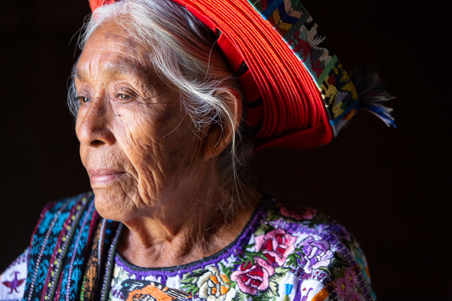
Santiago Atitlán
Discover the vibrant culture and stunning landscapes of Santiago Atitlán,…
Read MoreSan Pedro Sacatepéquez
Discover the rich culture, vibrant markets, and historical landmarks of…
Read More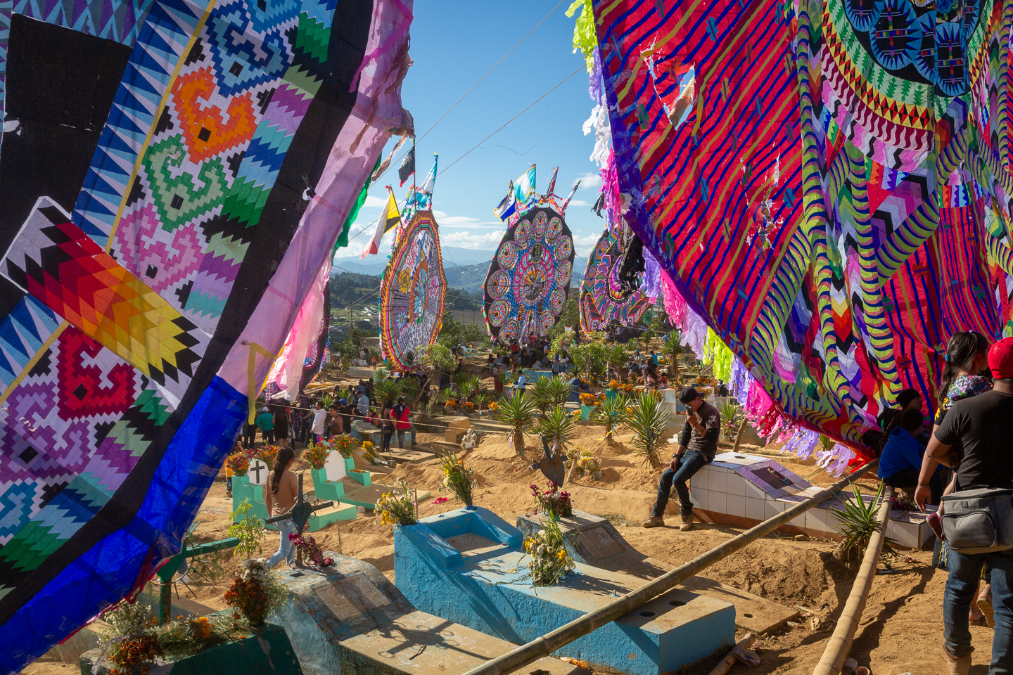
Top 5 Attractions
Casa Del Tejido (San Juan La Laguna – Atitlan)
Read More
Sunset in Santiago Atitlan
Santiago Atitlán offers a tranquil setting to watch the sunset, with the volcanoes and the lake providing a picturesque backdrop.
Read MoreSunset from the Keys of Panajachel
The keys of Panajachel are another great spot to watch the sunset over Lake Atitlán, offering a slightly different perspective.
Read MoreSunset from the Keys of San Marcos La Laguna
The keys of San Marcos La Laguna offer one of the best spots to watch the sunset over Lake Atitlán.
Read More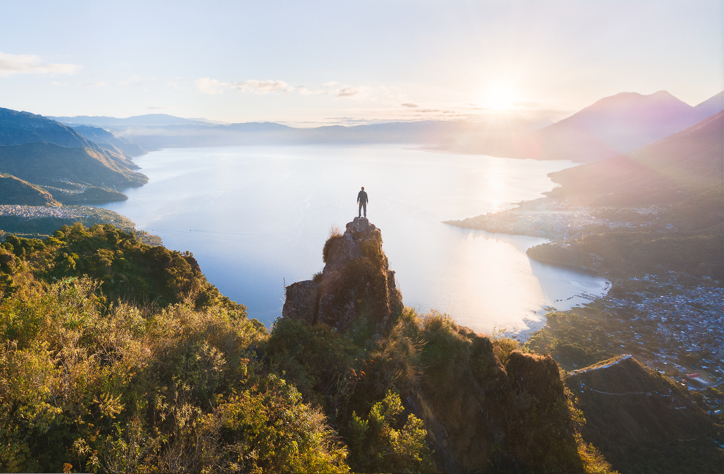
Rostro Maya (Nariz del Indio)
Rostro Maya, also known as Nariz del Indio, is a popular hiking spot near San Juan la Laguna, offering stunning views of Lake Atitlán and the surrounding volcanoes.
Read MoreTours and Day Trips
Lake Atitlán & Villages Tour
Discover the breathtaking beauty of Lake Atitlán, often called the most beautiful lake in the world, surrounded by volcanoes and dotted with charming indigenous villages. Travelers can explore towns like Panajachel, San Pedro La Laguna, and Santiago Atitlán, each offering unique handicrafts, vibrant markets, and rich Mayan culture. Boat rides across the lake provide stunning views, and visits to local cooperatives highlight traditional weaving techniques. Ideal for culture lovers, photographers, and families.
Chichicastenango Market Day Trip
Immerse yourself in one of Central America’s most famous markets, held every Thursday and Sunday in Chichicastenango. This bustling hub is a kaleidoscope of colors, with vendors selling textiles, pottery, and fresh produce. Visitors can witness traditional Mayan ceremonies at the nearby Santo Tomás Church and haggle for unique souvenirs. The market is a short drive from the Western Highlands and perfect for shoppers, history enthusiasts, and those eager to experience local life.
Hiking the Santa María Volcano
For adventure seekers, a sunrise hike up Santa María Volcano offers unparalleled views of the surrounding highlands and the active Santiaguito Volcano. The challenging 4-5 hour ascent rewards hikers with a panoramic vista of Guatemala’s volcanic landscape. This full-day excursion requires moderate fitness but is a must for nature lovers and photographers. Guides often include stops in nearby Quetzaltenango (Xela) for a taste of the region’s coffee culture.
Fuentes Georginas Hot Springs
Relax in the lush, steamy paradise of Fuentes Georginas, a natural hot spring nestled in the cloud forest near Zunil. These thermal pools, heated by volcanic activity, are perfect for unwinding after exploring the highlands. Visitors can enjoy the serene surroundings, hike nearby trails, or indulge in a local massage. Suitable for families, couples, and travelers seeking tranquility.
Iximché Archaeological Site & Cultural Tour
Step back in time at Iximché, the ancient Kaqchikel Maya capital, where well-preserved ruins sit atop a forested plateau. This half-day tour includes insights into Mayan history and rituals, with opportunities to witness traditional ceremonies. Located just outside Tecpán, the site is easily accessible from the Western Highlands and appeals to history buffs and those interested in indigenous heritage.
What to pack
What to Pack for the Western Highlands
The Western Highlands of Guatemala are known for their cool mountain climate, rugged terrain, and vibrant indigenous culture. Packing smartly means preparing for chilly mornings, sunny afternoons, and occasional rain showers—all while respecting local customs.
Clothing & Layers
- Lightweight but Warm Layers: Days can be warm, but temperatures drop sharply at night. Pack fleece or wool sweaters and a compact down jacket.
- Waterproof Shell or Poncho: Sudden rain showers are common, especially in the wet season (May–October).
- Modest Clothing for Villages: Many indigenous communities appreciate covered shoulders and knees. A shawl or scarf is versatile for warmth and cultural sensitivity.
Footwear
- Sturdy Hiking Shoes or Boots: Essential for exploring volcanic trails, cobblestone streets, and uneven terrain.
- Comfortable Walking Sandals: Great for warmer days in towns like Antigua or Lake Atitlán.
Gear & Accessories
- Daypack with Rain Cover: Keeps essentials dry during hikes or market visits.
- Reusable Water Bottle with Filter: Tap water isn’t safe to drink; a filter saves money and plastic waste.
- Sun Protection: High altitude means stronger UV rays—pack sunglasses, a wide-brimmed hat, and high-SPF sunscreen.
- Cash in Small Bills: Many rural markets and transport services don’t accept cards.
Extras
- Spanish Phrasebook or App: English isn’t widely spoken outside tourist hubs.
- Hand Sanitizer & Toilet Paper: Public restrooms often lack supplies.
Getting there
By Air
The nearest major international airport to the Western Highlands is La Aurora International Airport (GUA) in Guatemala City. From here, travelers can reach the region by:
- Domestic flights: Limited options to regional airports like Quetzaltenango (AAZ), but most travelers opt for ground transportation.
- Shuttle or private transfer: Pre-booked shuttles or taxis are available directly to towns like Antigua, Quetzaltenango (Xela), or Lake Atitlán (3-4 hours).
- Rental car: A 4x4 is recommended for some rural routes, especially in rainy season. Major highways like CA-1 (Interamericana) connect Guatemala City to the Western Highlands.
By Bus/Coach
Long-distance buses are the most common and affordable way to reach the Western Highlands from Guatemala City or other regions:
- From Guatemala City: Direct buses to Quetzaltenango (Xela), Huehuetenango, or Sololá (for Lake Atitlán) depart from Terminal de Transportes or private company terminals (e.g., Linea Dorada, Alamo). Travel time: 4-5 hours.
- From Antigua: Frequent shuttles or chicken buses (local buses) to Panajachel (Lake Atitlán) or Xela (3-4 hours).
- Tip: Book first-class buses in advance for comfort; chicken buses are cheaper but crowded.
By Car (Driving)
Driving to the Western Highlands offers flexibility but requires caution:
- Major routes: CA-1 (Interamericana) runs from Guatemala City through Quetzaltenango to Huehuetenango. CA-14 connects to Lake Atitlán.
- Road conditions: Highways are paved but mountainous; secondary roads may be rough or unpaved. A 4x4 is advisable for remote areas.
- Travel times: Guatemala City to Xela (~4 hours); Antigua to Lake Atitlán (~2.5 hours).
Practical Advice
Key tips for reaching the Western Highlands smoothly:
- Airport transfers: Pre-arrange shuttles from GUA to avoid inflated taxi prices.
- Bus travel: Daytime travel is safer; secure luggage and keep valuables close.
- Driving: Fuel up in cities; gas stations are sparse in rural areas. Watch for fog on highland roads.
Getting around
Public Buses (Chicken Buses)
The backbone of local transport in the Western Highlands, chicken buses (colorfully repurposed U.S. school buses) are cheap and frequent, connecting towns like Quetzaltenango (Xela), Huehuetenango, and smaller villages. Routes are informal but well-established—ask locals or your accommodation for the nearest pickup spot. Fares are paid in cash (usually 5–20 GTQ, depending on distance). Note: buses can be crowded and luggage space is limited.
- Tip: Arrive early for seats, and confirm the bus’s destination with the ayudante (assistant) before boarding.
- Advantage: Authentic experience and unbeatable prices.
- Disadvantage: No fixed schedules; delays are common on mountainous routes.
Taxis and Ride-Sharing
Taxis are widely available in larger towns like Xela and Huehuetenango, but always negotiate the fare beforehand (short rides: 20–40 GTQ; inter-town trips: 100+ GTQ). Ride-sharing apps like Uber operate sparingly in Xela but are unreliable elsewhere. For safety, use taxis recommended by hotels or restaurants.
- Tip: Shared taxis (colectivos) run fixed routes between towns and are cheaper than private hires.
Walking and Cycling
Many towns, especially Xela, are walkable with compact centers. Hiking between villages (e.g., Xela to Laguna Chicabal) is popular but requires a guide in remote areas. Bike rentals (50–100 GTQ/day) are available in Xela for exploring nearby valleys, though mountainous terrain can be challenging.
- Tip: Wear sturdy shoes—cobblestone streets and steep hills are common.
Tuk-Tuks and Microbuses
In smaller towns like San Pedro La Laguna (Lake Atitlán), tuk-tuks zip around for short trips (10–25 GTQ). Microbuses (minivans) supplement chicken buses on busy routes (e.g., Panajachel to Sololá) and cost slightly more but are faster.
Car and Scooter Rentals
Renting a car (from ~300 GTQ/day) is feasible for experienced drivers, but narrow, winding roads and loose livestock pose challenges. Scooters (150–250 GTQ/day) are better for short distances, like exploring Lake Atitlán’s villages. Always check insurance coverage.
- Disadvantage: Parking is scarce in towns, and roadside breakdowns can be tricky.
Unique Transport: Pickup Truck "Camionetas"
In rural areas, locals (and adventurous travelers) hitch rides in the backs of pickup trucks ("camionetas") for off-road routes to villages like Todos Santos. Pay the driver a small fee (10–20 GTQ). Not the safest option but a cultural experience.
Culture
Cultural Identity
The Western Highlands of Guatemala are a vibrant tapestry of Indigenous Maya traditions and colonial influences, creating a cultural identity distinct from the rest of the country. This region is home to over a dozen Maya ethnic groups, including the K'iche', Mam, and Kaqchikel, each preserving their own languages, weaving techniques, and spiritual practices. The highland towns are known for their ferias (festivals) and markets, where centuries-old customs thrive alongside contemporary life.
Language & Dialects
While Spanish is widely spoken, many communities in the Western Highlands communicate primarily in Indigenous languages. Each town often has its own linguistic nuances—K'iche' dominates around Quetzaltenango, while Mam is prevalent near Huehuetenango. Visitors may hear greetings like "Saqarik" (good morning in K'iche') or "Chjonte" (thank you in Mam), reflecting the region's linguistic diversity.
Traditional Attire & Textiles
The Western Highlands are famed for their handwoven textiles, with each community producing distinct patterns and colors. Huehuetenango is known for its intricate geometric designs, while Sololá features bold stripes. Women often wear cortes (wrap skirts) and huipiles (embroidered blouses) tied to their ancestral identity. Markets like Chichicastenango and Totonicapán are hubs for these textiles, where bargaining is expected but respect for artisans is paramount.
Festivals & Rituals
Religious syncretism defines many highland celebrations. The Fiesta de Santo Tomás in Chichicastenango blends Catholic saints' days with Maya rituals like the Palo Volador (flying pole dance). Semana Santa (Holy Week) in Quetzaltenango features elaborate alfombras (sawdust carpets) and processions. Smaller villages honor local patron saints with marimba music, fireworks, and communal feasts.
Cuisine
Highland cuisine revolves around maize, beans, and chilies, but regional specialties stand out. Boxboles (corn dough balls wrapped in chaya leaves) are a delicacy in Alta Verapaz, while atol de elote (sweet corn drink) is a breakfast staple. Markets serve caldo de res (beef soup) with hand-pressed tortillas. Coffee from Huehuetenango is globally renowned, often grown on small family farms using traditional methods.
Music & Dance
The marimba is the soul of highland music, often played at festivals and gatherings. Traditional dances like the Baile de la Conquista reenact historical events with vibrant costumes. In Totonicapán, brass bands accompany processions, while Nahualá is known for its drum-heavy sones (folk tunes).
Social Customs
Respect for elders and communal decision-making remain central in highland Maya communities. Visitors should ask permission before photographing people or sacred sites. Many towns operate under usos y costumbres (customary laws), where local councils resolve disputes. Sharing food or a tuj (sauna) is a gesture of trust.
Could not load FAQs. Please try again later.