Geography of Argentina
Explore Argentina's diverse landscape, from Andean peaks to Pampas plains.
Argentina: a nation that conjures images of vast plains, towering mountains, and a spectacular coastline. But what truly defines this South American giant? If you're curious about the diverse landscapes that shape Argentina, you've come to the right place.
This article will take you on a journey through Argentina's incredible geographic tapestry, from its extreme elevations and depressions to its major regions and vital waterways. Prepare to discover the natural forces that have sculpted this captivating country.
Essentials
A Land of Geographic Extremes
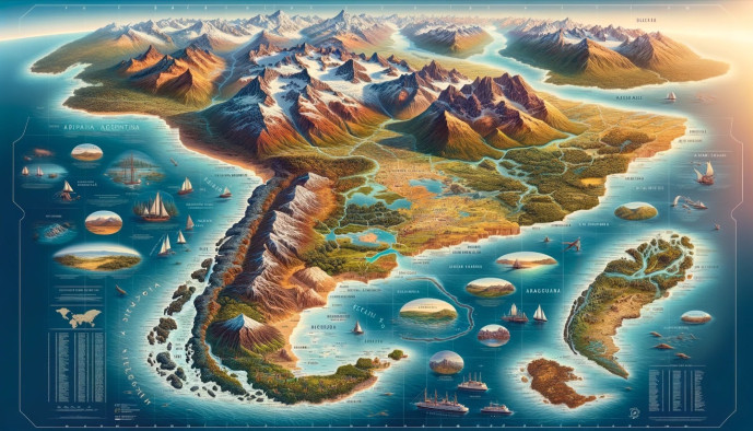
Argentina’s identity is shaped by its immense scale and dramatic contrasts. From subtropical jungles in the north to subpolar ice fields in the south, the country encompasses a staggering diversity of landscapes, climates, and ecosystems. This variety is not just a matter of latitude; it is a product of a unique geographic position, where the towering Andes meet vast fertile plains and a long, wild coastline. To understand Argentina is to understand the powerful forces of its geography, which have dictated everything from its history and economy to the resilient character of its people.
Location, Size, and Borders
Occupying a significant portion of southern South America, Argentina is a country of continental proportions. It is the eighth-largest country in the world by land area, stretching from the Tropic of Capricorn far into the cold reaches of the Southern Hemisphere. Its western edge is defined by the formidable Andes mountain range, which creates a natural and extensive border with its neighbor, Chile.
To the north, Argentina shares borders with Bolivia and Paraguay in the hot, dry Gran Chaco region. In the northeast, its frontiers with Brazil and Uruguay are traced by major rivers, creating a lush, water-rich area known as Mesopotamia. The country’s entire eastern flank is met by the South Atlantic Ocean, giving it a vast and varied coastline that extends for nearly 5,000 kilometers. This strategic location provides it with crucial access to Atlantic maritime routes while anchoring it firmly within the South American continent.
Administrative Divisions
Argentina is organized as a federal republic, a structure that reflects the distinct identities and histories of its various regions. The nation is composed of 23 provinces and one autonomous city, Buenos Aires. Each province has its own constitution and enjoys considerable autonomy, managing its own justice system, security, and local governance. This federal system allows for regional differences to be expressed politically and culturally.
The City of Buenos Aires holds a unique status. While it serves as the nation’s capital, it is not part of the Province of Buenos Aires. As an autonomous city, it functions with a level of self-governance similar to that of a province, electing its own head of government and legislature. This political geography concentrates significant power and population in the capital, creating a dynamic and often tense relationship with the vast provinces that make up the rest of the country.
The Major Geographic Regions
Argentina’s vast territory is not a monolith; instead, it is a mosaic of distinct geographical regions, each with its own unique landscape, climate, and character. From towering mountain peaks to fertile plains and arid plateaus, the country’s diversity is one of its most defining features.
The Andes Mountains
Stretching like a colossal spine along the entire western edge of Argentina, the Andes Mountains form a formidable natural border with neighboring Chile. This is a realm of dramatic peaks, deep valleys, and stark, high-altitude landscapes. It is here that one finds Aconcagua, which at 6,961 meters (22,838 feet) is not only Argentina’s highest point but the highest mountain in both the Western and Southern Hemispheres. In the country’s northwest, the main cordillera broadens into a series of high, arid plateaus known as the Puna or Altiplano, a windswept region of salt flats and volcanic cones that feels otherworldly.
The Pampas
At the heart of Argentina lies its most iconic landscape: the Pampas. These are vast, extraordinarily fertile plains that stretch across the central-eastern part of the country. This region is the soul of Argentina’s agricultural identity, a seemingly endless expanse of grasslands that has supported cattle ranching and grain production for centuries. The Pampas are generally divided into two zones: the Humid Pampa to the east, which receives ample rainfall for intensive farming, and the Dry Pampa to the west, which transitions into a more arid environment. It is also the nation’s demographic core, home to the majority of the population and the sprawling metropolitan area of Greater Buenos Aires.
Patagonia
To speak of Patagonia is to invoke images of the sublime and the untamed. This immense southern region is a land of profound emptiness and staggering beauty, defined by its sparse population and dramatic, windswept landscapes. It is a territory of contrasts, neatly split between the west and the east. Andean Patagonia is a wonderland of jagged, ice-capped peaks, deep-blue glacial lakes, and dense temperate forests. Further east, the landscape transforms into the vast Patagonian Plateau, an arid and seemingly infinite steppe that rolls towards the Atlantic. This remote corner of the world includes the island archipelago of Tierra del Fuego, the southernmost tip of the South American continent, a place that truly feels like the end of the earth.
Gran Chaco
In the north of Argentina, the Gran Chaco is a vast, hot, and semi-arid lowland region shared with Paraguay, Bolivia, and Brazil. Its landscape is a mix of thorny scrubland, dry forests, and savannahs, subject to some of the highest temperatures on the continent during the summer months. The Chaco is a challenging environment, both for its inhabitants and its ecosystem. It is an area of significant biodiversity but also faces serious environmental pressures, most notably high rates of deforestation driven by the expansion of agriculture.
Mesopotamia
Nestled between the two great rivers of the Paraná and the Uruguay, the region known as Mesopotamia is Argentina’s version of a fertile crescent. This humid, subtropical land is characterized by rolling green hills, dense rainforests, and expansive wetlands. Its water-rich environment supports a lush and vibrant ecosystem. Mesopotamia is home to the incredible Iberá Wetlands, one of the largest protected freshwater marshlands on the planet and a sanctuary for diverse wildlife. It is also here, on the border with Brazil, that the earth seems to split open to create the magnificent Iguazú Falls, one of the world’s most spectacular natural wonders.
Cuyo
Located in west-central Argentina, at the arid foothills of the Andes, lies the Cuyo region. This area is defined by its dry, sunny climate, receiving very little rainfall throughout the year. Yet, it is this very climate, combined with high altitudes and irrigation from rivers fed by Andean snowmelt, that has turned Cuyo into Argentina’s premier wine-producing region. The provinces of Mendoza, San Juan, and San Luis are synonymous with Argentinian wine, particularly the world-renowned Malbec. The landscape is a striking contrast of dusty, ochre-colored earth and the orderly green geometry of vineyards stretching towards the towering mountains in the distance.
Hydrography: Rivers, Lakes, and Coastline
Water is a defining feature of Argentina’s geography, carving its landscapes, sustaining its ecosystems, and shaping its human history. From colossal river basins in the north to frozen ice fields in the south, the country’s hydrography is as varied as its terrain.
Major River Systems
The lifeblood of northern and central Argentina is the Río de la Plata Basin, the second-largest drainage basin in South America after the Amazon. This immense system is fed by three powerful rivers. The Paraná River, the basin’s main artery, flows southward, creating vast floodplains and deltas. It is joined by the Paraguay River from the north and flanked by the Uruguay River to the east, which forms a natural border. These waterways have historically been fundamental to the nation’s development, serving as crucial corridors for transportation and trade. They are also a significant source of energy, with massive hydroelectric projects like the Yacyretá Dam harnessing their power. The fertile banks of these rivers have nurtured settlement and agriculture for centuries, supporting some of the country’s most populous areas.
Lakes, Wetlands, and Glaciers
Argentina’s still waters present a landscape of dramatic contrasts. In the south, Andean Patagonia is dotted with deep, crystalline lakes of glacial origin. Among the most renowned are Lago Argentino, the country’s largest freshwater lake, and the picturesque Nahuel Huapi Lake, set against a backdrop of snow-capped peaks. In sharp contrast, central Argentina is home to Mar Chiquita, a vast endorheic salt lake that supports a unique ecosystem and is a vital stop for migratory birds. Further south lies one of the world’s great natural wonders: the Southern Patagonian Ice Field. This immense expanse of ice is the third-largest reserve of fresh water on the planet, feeding numerous glaciers that carve their way through the mountains. Discover more about the top tourist sites in Patagonia, many of which are defined by these stunning glacial features.
The Atlantic Coast
Stretching for nearly 5,000 kilometers (3,100 miles), Argentina’s Atlantic coastline is a long and varied frontier between land and sea. It is home to important commercial and fishing ports, such as the bustling resort city of Mar del Plata and the deep-water port of Bahía Blanca, which are critical to the national economy. The coastline’s most remarkable feature, however, is the Valdés Peninsula in Patagonia. Recognized as a UNESCO World Heritage site, this protected area is a globally significant sanctuary for marine life. Its sheltered bays provide a crucial breeding ground for the southern right whale, while its shores are home to large colonies of sea lions, elephant seals, and Magellanic penguins, making it a premier destination for wildlife observation. Learn more about why you should visit Argentina, and the incredible natural wonders it offers.
A Spectrum of Climates
Argentina’s immense longitudinal range, stretching from the tropics to the subantarctic, creates a remarkable mosaic of climates. Traveling through the country is like traversing a continent in itself, with each region offering a distinct atmospheric character shaped by latitude, altitude, and proximity to the ocean.
Northern Subtropical Climate
The northern reaches of Argentina, encompassing regions like Mesopotamia and the Gran Chaco, are defined by a subtropical climate. Summers are hot and humid, often punctuated by heavy rainfall that sustains the lush rainforests and wetlands. Winters, in contrast, are generally mild and significantly drier, offering a pleasant respite from the intense summer heat. This climate is responsible for the vibrant ecosystems found at Iguazú Falls and the Iberá Wetlands. For an immersive experience, consider a visit to the Foz Do Iguaçu, a natural spectacle powered by this climate.
Central Temperate Climate
The vast agricultural heartland of the Pampas experiences a temperate climate with four well-defined seasons. Summers are warm to hot, ideal for the cultivation of grains and for grazing livestock. Autumn brings cooler, crisp air and changing foliage, leading into mild to cool winters that can occasionally see frosts but rarely significant snowfall. Spring is a period of renewal, making this central zone, including Buenos Aires, climatically comfortable for much of the year.
Western Arid Climate
In the shadow of the Andes lies the Cuyo region, characterized by an arid, continental climate. This area receives very little rainfall, resulting in a desert-like landscape. The defining feature is the significant daily temperature range; days are intensely sunny and hot, while nights can become surprisingly cold. This combination of abundant sunshine and dry air, moderated by irrigation from Andean rivers, creates the perfect conditions for the celebrated Malbec grapes of Mendoza. Our comprehensive travel guide to Mendoza can help you explore this wine-producing paradise.
Southern Subpolar Climate
Patagonia and the island of Tierra del Fuego are subject to a cold, windy, and often-unpredictable subpolar climate. The influence of the Andes and the proximity to Antarctica create a dramatic environment. Summers are short and cool, with daylight stretching late into the evening. Winters are long and cold, with significant snowfall, particularly in the mountainous areas. The persistent Patagonian wind is a constant feature, shaping both the landscape and the resilient character of the region. When planning your trip to this region, it’s important to consider money matters in Patagonia and how to stay connected with our guide on internet, SIM cards, and phones.
Iconic Natural Wonders and Landmarks
Argentina’s vast and varied geography has produced some of the world’s most breathtaking natural spectacles. From thundering waterfalls in the jungle to silent, advancing glaciers in the south, these landmarks are not just tourist destinations but integral parts of the country’s identity and ecological heritage.
Iguazú Falls
Located on the border with Brazil, the Iguazú Falls (Cataratas del Iguazú) are a staggering system of hundreds of waterfalls that cascade over cliffs and islets. Set within the lush subtropical rainforest of Iguazú National Park, the falls are a powerful display of nature’s force. The sheer volume of water, the constant roar, and the perpetual mist create an immersive sensory experience. The most impressive section, a U-shaped chasm known as the Garganta del Diablo (Devil’s Throat), channels nearly half of the river’s flow into a dramatic plunge. For more on this natural wonder, check out our comprehensive travel guide to Foz Do Iguaçu.
Perito Moreno Glacier
In the heart of Patagonian wilderness lies the Perito Moreno Glacier, one of the most accessible and dynamic ice fields on the planet. Situated in Los Glaciares National Park, this immense glacier is remarkable because it is one of the few in the world that is advancing rather than retreating. Visitors can walk along extensive boardwalks to witness its towering 60-meter (200-foot) ice wall. The glacier is famous for its dramatic ruptures, where massive icebergs calve from its face and crash into Lago Argentino with a thunderous roar, a powerful and unforgettable spectacle. Learn more about this incredible region in our guide to the top tourist sites in Patagonia.
Quebrada de Humahuaca
The Quebrada de Humahuaca is a narrow, arid mountain valley in the northwestern province of Jujuy, recognized as a UNESCO World Heritage site for its rich cultural and natural history. The valley is renowned for its stunning geological formations and the vibrant mineral palettes that color its mountainsides. The most iconic of these is the Cerro de los Siete Colores (Hill of Seven Colors) in the village of Purmamarca, where sedimentary layers have been exposed to create a breathtaking spectrum of reds, greens, purples, and yellows.

The Valdés Peninsula
Projecting into the South Atlantic Ocean, the Valdés Peninsula is a globally significant nature reserve and a premier destination for marine wildlife observation. This UNESCO World Heritage site is a critical breeding ground for several protected species. From June to December, it becomes a sanctuary for the endangered southern right whale, which comes to the sheltered gulfs to mate and give birth. The peninsula’s coastline is also home to bustling colonies of sea lions, elephant seals, and Magellanic penguins, making it a vital hub of marine biodiversity.
Human Geography and Natural Resources
Population Distribution
The geography of Argentina has profoundly shaped where its people live, resulting in one of the most uneven population distributions in South America. The vast majority of Argentinians are concentrated in the central-eastern part of the country, within the fertile plains of the Pampas. The Greater Buenos Aires metropolitan area, in particular, serves as the nation’s demographic, economic, and cultural nucleus, housing roughly a third of the entire population.
This dense core stands in stark contrast to the immense, near-empty landscapes that characterize much of the rest of the country. Regions like southern Patagonia and the northern Gran Chaco are among the most sparsely populated areas on the planet. This pattern is a direct legacy of the country’s development, with historical settlement and modern urbanization closely following the agricultural and economic hubs established on the most productive lands. For a deeper understanding of the region’s physical characteristics, explore our overview of Patagonia’s geography.
Economic Geography and Resources
Argentina’s diverse landscapes are endowed with a wealth of natural resources that form the bedrock of its economy. Each geographic region contributes a unique set of assets.
The Pampas region is the undisputed agricultural heartland. Its deep, fertile soils and temperate climate make it ideal for large-scale farming. It is a global leader in the production of soybeans, corn, and wheat. This is also the historic domain of the gaucho and the source of Argentina’s world-famous beef, with vast ranches, or estancias, dotting the plains.
To the west, in the arid Cuyo region, viticulture thrives. Nestled in the foothills of the Andes, provinces like Mendoza have gained international acclaim for their wine production, particularly Malbec. The industry relies on a system of irrigation channels, fed by the snowmelt from the high peaks, that transforms the dry landscape into a mosaic of lush vineyards. Planning a trip to this wine region? Our complete travel guide to Mendoza will be invaluable.
The high-altitude plateau of the Puna in the northwest holds significant mineral wealth. This region is part of the “Lithium Triangle,” containing some of the world’s largest reserves of lithium, a critical component for batteries. The Andes also yield valuable deposits of copper, gold, and silver.
In terms of energy, Patagonia is a key region. It holds significant reserves of oil and natural gas, most notably within the Vaca Muerta formation, one of the largest shale oil and gas deposits in the world. Finally, the country’s spectacular and varied geography is itself a major resource, driving a vibrant tourism industry. From the thundering Iguazú Falls to the advancing glaciers of Patagonia, these natural wonders attract visitors from across the globe, making tourism a vital component of the national economy. Consider exploring other parts of this vast region with our guide to lodging and camping in Patagonia.